
NCERT Solutions For Class 6 Geography Chapter 6 Our Country India
Question 1. If we divide the world into Eastern and Western Hemispheres which hemisphere would India belong to?
Answer: India belongs to the Eastern Hemisphere.
Question 2. Do you remember how many time zones are there in Russia?
Answer: Yes, I remember that Russia has eleven time zones.
Question 3. There are seven countries that share land boundaries with India. Find out the names of these countries.
Answer: The names of the seven countries that share land boundaries with India are as follows
- China
- Nepal
- Bhutan (North
- Pakistan
- Afghanistan (North-West)
- Bangladesh
- Myanmar (North)
Question 4. India shares its land boundary with seven countries. How many of these countries do not have access to any ocean or sea?
Answer: There are three neighboring countries of India among seven countries that do not have access to any ocean or sea. These are Afghanistan, Bhutan and Nepal.
Question 5. Find out the names of five hill stations situated in Himachal or Middle Himalaya.
Answer: Chail, Dalhousie, Dharamsala, Kullu, and Manali are some hill stations situated in Himachal or the middle Himalayas.
Question 6. Many girls are named after rivers, For Example. Yamuna, Mandakini and Kaveri. Do you know anyone in your locality who is named after a river? Ask your parents and others and make a list of such names. Could you also find other names related to water For Example? Shabnam?
Answer: Yes, I know some girls in my locality who are named after rivers. Ganga, Krishna, and Kali are these girls. The other names related to water are Godavari, Tapi, Mahi, Ravi, Nubra, etc.
NCERT Solutions for Class 6 Geography Chapter 6 Our Country India
Question 7. Which group of islands were affected by the Tsunami in 2004?
Answer: The Andaman and Nicobar Islands were affected by the Tsunami in 2004.
Geography Chapter 6 Our Country India Exercises
Question 1. Answer the following questions briefly.
(1) Name the major physical divisions of India.
Answer: The major physical divisions of India are the Himalayas, the Northern Indian Plains, the Great Indian Desert, the Peninsular Plateau, the Coastal Plains, and the Group of Islands.
(2) India shares its land boundaries with seven countries. Name them.
Answer: India shares its land boundaries with seven countries that are Pakistan, Afghanistan, Nepal, Bhutan, China, Bangladesh and Myanmar.
(3) Which two major rivers fall into the Arabian Sea?
Answer: The two major rivers Narmada and Tapi fall into the Arabian Sea.
(4) Name the delta formed by the Ganga and the Brahmaputra.
Answer: The Sundarbans Delta is formed by the Ganga and the Brahmaputra.
Our Country India NCERT Solutions Class 6
(5) How many States and Union Territories are there in India? Which states have a common capital?
Answer: There are 28 States and 8 Union Territories in India. Punjab and Haryana have a common capital, i.e. Chandigarh.
(6) Why do a large number of people live in the Northern plains?
Answer: A large number of people live in the Northern plains because the Northern Indian plains are generally level and flat. These are formed by the alluvial deposits laid down by the rivers i.e. the Indus, the Ganga, the Brahmaputra, and their tributaries. These river plains provide fertile land for cultivation.
(7) Why are Lakshadweep Islands known as coral islands?
Answer: Lakshadweep Islands are known as coral islands because these are made up of coral reefs which are skeletons of tiny marine animals called polyps.
Question 2. Tick the correct answers.
(1) The Southernmost Himalayas are known as
- Shiwaliks
- Himadri
- Himachal
Answer: 1. Shiwaliks
(2) Sahyadris is also known as
- Aravali
- Western Ghats
- Himadri
Answer: 2. Western Ghats
(3) The Palk Strait lies between the countries
- Sri Lanka and Maldives
- India and Sri Lanka
- India arid Maldives
Answer: 2. India and Sri Lanka
(4) The Indian islands in the Arabian Sea are known as
- Andaman and Nicobar Islands
- Lakshadweep Islands
- Maldives
Answer: 2. Lakshadweep Islands
Class 6 Geography Chapter 6 NCERT Solutions
(5) The oldest mountain range in India is the
- Aravali mountains
- Western Ghats
- Himalayas
Answer: 1. Aravali mountains
Question 3. Fill in the blanks.
1. India has an area of about ……
Answer: 3.28 million sq. km
2. The Greater Himalayas are also known as ……
Answer: Himadri
3. The River Narmada falls into the …….. sea.
Answer: Arabian
4. The latitude that runs almost halfway through India is …….
Answer: Tropic of Cancer
Geography Chapter 6 Our Country India Multiple Choice Questions (MCQs)
Question 1. What is the North-South extent of India from Kashmir to Kanyakumari?
- About 5,400 km
- About 2,900 km
- About 3,200 km
- About 16,990 km
Answer: 3. About 3,200 km
Question 2. India is situated in which hemisphere?
- Northern
- Southern
- Western
- Eastern
Answer: 1. Northern
NCERT Solutions for Class 6 Geography Chapter 6 PDF
Question 3. The Tropic of Cancer is located at
- 23°30′ N
- 26°30′ N
- 30°30′ S
- 23°30′ S
Answer: 1. 23°30′ N
Question 4. The West-East extension of India is
- 8°4′ N and 37°6′ N
- 68°7′ E and 97°25′ E
- 68°7′ N and 97°25′ N
- 8°4′ E and 37°6′ E
Answer: 2. 68°7′ E and 97°25′ E
Question 5. What is the local time of longitude that has been taken as the Indian Standard Time?
- 82°30’E
- 23°30′ N
- 68°7′ E
- 97°25’E
Answer: 1. 82°30’E
Question 6. How many time zones are there in the USA and Canada?
- 6 and 7
- 7 and 6
- 4
- 5
Answer: 2. 7 and 6
Question 7. Which is not a neighboring country of India?
- China
- Myanmar
- Thailand
- Bangladesh
Answer: 3. Thailand
Question 8. The Himalayan mountains are divided into how many parallel ranges?
- 5
- 10
- 4
- 3
Answer: 4. 3
Our Country India Geography Class 6 NCERT Notes
Question 9. Choose the river(s) of the Indian Plain among the following.
- Ganga
- Brahmaputra
- Indus
- All of these
Answer: 4. All of these
Question 10. “Raghav Desai is an industrial entrepreneur and looking for a nice place to set up his industry, that deals with iron and related metals.”
Which according to you, should be the place where he will find availability of resources for his industry/ plant?
- The Himalayas
- The Northern Plains
- The Coastal Plains
- The Peninsular Plateau
Answer: 4. The Peninsular Plateau
Question 11. Identify the physical division of India that is/are being discussed in the statements below,
- They are generally flat and level.
- They are formed by the alluvial deposits.
- The Ganga and the Brahmaputra form the largest delta of the world in this division.
Options
- The Northern Plains
- The Coastal Plains
- The Islands
- The Western Plains
Answer: 1. The Northern Plains
Question 12. Which of the following statements is/are correct?
- India has an area of 3.28 million sq. km.
- North-South extension from Ladakh to Kanyakumari is about 2900 km.
- East-West extension from Arunachal Pradesh to Kuchchh is about 3,200 km.
Codes
- Only 1
- Both 1 and 2
- Both 2 and 3
- 1, 2 and 3
Answer: 1. Only 1
NCERT Solutions Class 6 Geography Chapter 6 PDF
Question 13. Which of the following statements Is/are correct?
- The Indian Standard Time is 82° 30′ W.
- Nepal, Bhutan, and China are the Northern neighbors of India.
- Lakshadweep and Andaman and Nicobar Islands lie in the Bay of Bengal and the Arabian Sea respectively.
Codes
- Only 1
- Both 2 and 3
- Both 1 and 2
- Both 1 and 3
Answer: 3. Both 1 and 2
Question 14. Arrange the following neighbors of India from East to West.
- Nepal
- Myanmar
- Bhutan
- Pakistan
Codes
- 1, 2, 3, 4
- 2, 1, 4, 3
- 3, 2, 1, 4
- 4, 3, 2, 1
Answer: 3. 3, 2, 1, 4
Question 15. Arrange the following states through which the Tropic of Cancer passes in the West to East direction.
- West Bengal
- Madhya Pradesh
Codes
- 1, 2, 3, 4
- 2, 4, 1, 3
- 2, 3, 1, 4
- 4, 3, 2, 1
Answer: 2. 2, 4, 1, 3
Geography Chapter 6 Our Country India Match The Following
Question.
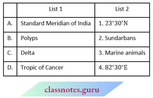
Codes
- A B C D
- 2 3 4 1
- 4 3 2 1
- 1 3 2 4
- 4 2 1 3
Answer: 2. 4 3 2 1
Chapter 6 Our Country India NCERT Solutions
Geography Chapter 6 Our Country India Assertion Reason
1. Assertion (A) The Ganga and the Brahmaputra form the world’s largest delta, the Sundarbans delta.
Reason (R) The delta is triangular in shape, and an area of land formed at the mouth of the river.
Codes
- Both A and R are true and R is the correct explanation of A
- Both A and R are true, but R is not the correct explanation of A
- A is true, but R is false
- A is false, but R is true
Answer: 1. Both A and R are true and R is the correct explanation of A
2. Assertion (A) The Great Indian Desert lies in the Western part of India.
Reason (R) The rivers Narmada and Tapi flow Westward towards the Arabian Sea.
Codes
- Both A and R are true and R is the correct explanation of A
- Both A and R are true, but R is not the correct explanation of A
- A is true, but R is false
- A is false, but R is true
Answer: 2. Both A and R are true, but R is not the correct explanation of A
Geography Chapter 6 Our Country India Fill in the Blanks
Question 1. India is a country of vast ……… expanse.
Answer: geographical
Question 2. The ……. is a piece of land that is surrounded by water on three sides.
Answer: peninsula
Question 3. Many popular hill stations are situated in the ………. Himalayas.
Answer: Middle
Question 4. The Narmada and Tapi rivers flow between the …… and …….
Answer: Vindhyas, Satpura
NCERT Class 6 Geography Chapter 6 Our Country India
Question 5. India is the second most populated country in the world after …….
Answer: China
Geography Chapter 6 Our Country India True or False
Question 1. The Northern Indian plains lie to the North of the Himalayas.
Answer: False
Question 2. India is located in the Southern Hemisphere.
Answer: False
Question 3. Aravalli Hill is one of the oldest ranges in the world.
Answer: True
Question 4. The Tropic of Cancer (23 °30N) passes almost halfway through the country.
Answer: True
Geography Chapter 6 Our Country India Picture Based Question
Question 1. Look at the picture of the coral island given below and answer the following question.

Corals are skeletons of tiny marine animals called
- plants
- humans
- polyps
- horses
Answer: 3. polyps
Geography Chapter 6 Our Country India Case Based Question
1. Read the passage given below and answer the following questions.
- India is a country of vast geographical expanse. In the North, it is bound by the lofty Himalayas. The Arabian Sea in the West, the Bay of Bengal in the East, and the Indian Ocean in the South wash the shores of the Indian Peninsula.
- India has an area of about 3.28 million sq. km. The North-South extent from Ladakh to Kanyakumari is about 3,200 km and the East-West extent from Arunachal Pradesh to Kuchchh is about 2,900 km.
- The lofty mountains, the Great Indian Desert, the Northern plains, the uneven plateau surface, and the coasts and islands present a diversity of landforms. There is a great variety in the climate, vegetation, wildlife as well as in the language and culture.
- In this diversity, we find unity that is reflected in traditions that bind us as one nation. India has a population of more than one hundred twenty crores since the year 2011. It is the second most populous country in the world after China.
- India is located in the Northern Hemisphere. The Tropic of Cancer (23°30’N) passes almost halfway through the country. From South to North, the mainland of India extends between 8°4’N and 37°6’N latitudes. From West to East, India extends between 68°7’E and 97°25’E longitudes.
- Due to the great longitudinal extent of about 29°, there could be wide differences in the local time of places located at two extreme points of India.
(1) What is the reason for wide differences in local time in India?
- North-South extent
- East-West extent
- Population density
- Geographical location
Answer: 2. East-West extent
(2) The Himalayas do not lie in
- China
- Nepal
- Bhutan
- Bangladesh
Answer: 4. Bangladesh
(3) Godavari, Krishna and Kaveri are the rivers of
- Northern Plains
- Western Desert
- Deccan Plateau
- The Islands
Answer: 3. Deccan Plateau
Our Country India Geography Class 6 Solutions
(4) What is the geographical boundaries of India?
- Himalayas in the South
- Arabian Sea in the East
- Bay of Bengal in the West
- Indian Ocean in the South A
Answer: 2. Arabian Sea in the East
Geography Chapter 6 Our Country India Very Short Answer Type Question And Answers
Question 1. What is the geographical extent of India?
Answer: In India, the North-South extent from Kashmir to Kanyakumari is 3,200 km, and the East-West extent from Arunachal Pradesh to Kuchchh is about 2,900 Ion.
Question 2. What do you understand by Peninsula?
Answer: The Peninsula is a piece of land that is surrounded by water on three sides.
Question 3. How does local time vary?
Answer: The local time varies by four minutes for every one degree of longitude.
Question 4. What is the time difference between the time of sunrise in Arunachal Pradesh and Gujarat?
Answer: The difference between the time of sunrise in Arunachal Pradesh and Gujarat is two hours.
Question 5. What does the word ‘Himalaya’ mean?
Answer: Himalayas means ‘the abode of snow’.
Question 6. On which part of the Himalayas are the highest peaks located?
Answer: The world’s highest peaks are located in the Great Himalayas or Himadari.
Question 7. What do you understand by the term ‘desert’?
Answer: A desert is a dry, hot, and sandy stretch of land with very little vegetation.
NCERT Solutions for Geography Chapter 6 Class 6
Question 8. Write the name of the two important Peninsular Plateau hill ranges.
Answer: The Vindhyas and the Satpuras are the two important Peninsular plateaus.
Question 9. Differentiate between the Western Coastal plains and the Eastern Coastal plains.
Answer: The Western Coastal plains are very narrow while the Eastern Coastal plains are much broader.
Question 10. What do you call the point where rivers enter the sea?
Answer: The point where rivers enter the sea is called the mouth of the river.
Question 11. Write the name of the rivers which fall into the Bay of Bengal.
Answer: Mahanadi, Godavari, Krishna, Kaveri, Ganga, and Brahmaputra are the major rivers that fall into the Bay of Bengal.
Question 12. How are Coral Islands formed?
Answer: When the living polyps die, their skeletons are left. Other polyps grow on the top of the hard skeleton which grows higher and higher and thus forms coral islands.
Geography Chapter 6 Our Country India Short Answer Type Question And Answers
Question 1. Explain the effect of the East-West extent of India on time.
Answer:
- The East-West extent of India leads to differences in local time from meridian to meridian. The local time changes by four minutes for every one degree of longitude.
- The Sun rises two hours earlier in the East, i.e. Arunachal Pradesh than in the West, i.e. Gujarat. This longitude is also known as the Standard Meridian of India. Its time is taken as the standard throughout the country.
Question 2. Write at least three sentences about the economic importance of the Northern plains of India.
Answer:
The three sentences about the economic importance of the Northern plains of India are as follows
- Northern plains provide fertile land for cultivation and it has a sizeable contribution to the agricultural economy of India.
- Northern plains have deposits of various rivers which increases the presence of minerals in such soils.
- Various rivers flow through the Northern plains which make it an ideal place for setting up civilisations.
Question 3. List the rivers and important ranges of the Peninsular Plateau.
Answer:
- The peninsular plateau lies on the South of the Northern plains. Peninsular plateau is a region with numerous hill ranges and valleys.
- Aravalli hills, one of the oldest ranges of the world, border the plateau on the North-West side. The Vindhyas and the Satpuras are the important ranges in the Peninsular plateau. The rivers Narmada and Tapi flow through these ranges. These are West flowing rivers that drain into the Arabian Sea.
Question 4. Write a short note on the Coastal plains of India.
Answer:
- Coastal plains lie to the West of Western Ghats and to the East of Eastern Ghats. The Western Coastal plains are very narrow, whereas the Eastern Coastal plains are much broader.
- There are a number of east-flowing rivers. The rivers Mahanadi, Godavari, Krishna, and Kaveri drain into the Bay of Bengal. These rivers have formed fertile deltas at their mouth For Example. Sundarbans delta.
Question 5. Briefly describe the features of the Group of Islands.
Answer:
- Lakshadweep and the Andaman and Nicobar Islands are two groups of islands found in India.
- Lakshadweep Islands are located in the Arabian Sea. These are coral islands located off the coast of Kerala.
- The Andaman and Nicobar Islands lie to the southeast of the Indian mainland in the Bay of Bengal. These islands were affected by the Tsunami in 2004.
Question 6. “India has a vast geographical landscape and cultural and regional diversity. It has the Himalayas, the Great Indian Desert, the Northern plains, the Peninsular plateaus, the Coastal plains, and the Islands.”
(1) How does India’s geographical diversity contribute to its cultural and ecological richness?
Answer:
India’s geographical diversity contributes to its cultural and ecological richness as it supports a rich variety of flora and fauna, influencing cultural practices and traditions. Different regions have unique lifestyles, languages, and customs contributing to India’s cultural and ecological richness.
NCERT Solutions for Geography Chapter 6 Class 6
(2) How does India’s geographical location influence its trade and economic activities?
Answer:
India lies between the Middle East and South-East Asia. Its closeness to major water bodies like the Arabian Sea and the Bay of Bengal encourages maritime activities, supporting economic growth through trade, shipping, and access to global markets. In this way, India’s geographical location influences its trade and economic activities.
Geography Chapter 6 Our Country India Long Answer Type Question And Answers
Question 1. Explain the physical divisions of India.
Answer:
- The physical divisions of India include mountains, plateaus, plains, coasts, and islands.
- The Himalayan Mountains are divided into three main parallel ranges – the Great Himalaya or Himadri, the Middle Himalaya or Himachal, and the Shivalik.
- Northern Indian Plains lie to the South of the Himalayas and are generally level and flat.
- The great Indian Desert is found in the Western part of India. It consists of a dry, hot, and sandy stretch of land with very little vegetation.
- The Peninsular Plateau is situated to the South of the Northern plains. It is triangular in shape and its relief is highly uneven. Coastal plains lie to the West of Western Ghats and to the East of Eastern Ghats. The Western Coastal plains are very narrow, whereas the Eastern Coastal plains are much broader.
- Lakshadweep Islands are located in the Arabian Sea. The Andaman and Nicobar Islands lie to the southeast of the Indian mainland in the Bay of Bengal.
Question 2. Write a short note on the Himalayas in India.
Answer:
- The Himalayas are snowcapped mountains standing as sentinels in the North of India. Him and Alaya means the abode of snow.
- The Himalayan mountains are divided into three main parallel range
- The Great Himalayas or Himadri which is the Northern range. The world’s highest peaks are located in this range.
- Middle Himalaya or Himachal which lies to the South of Himadri.
- Many popular hill stations are situated here.
- The Shiwalik is the Southernmost range.
Question 3. “India is a country of vast geographical expanse. In the North, it is bounded by the lofty Himalayas. The Arabian Sea in the West, the Bay of Bengal in the East, and the Indian Ocean in the South wash the shores of the Indian Peninsula.”
Explain about the geographical extension and diversity in India.
Answer:
- India is a country with a large geographical expanse. It is surrounded by the lofty Himalayas in the North, the Arabian Sea in the West, the Bay of Bengal in the East, and the Indian Ocean in the South.
- India extends between 8°4’N and 37°6’N latitudes from South to North and between 68°7’E and 97°25’E longitudes from West to East.
Geography Chapter 6 Our Country India Case Based Question
1. Read the passage given below and answer the following questions that follow.
- Himalaya means ‘the abode of snow’. The Himalayan mountains are divided into three main parallel ranges. The Northernmost is the Great Himalayas or Himadri. The world’s highest peaks are located in this range.
- Middle Himalaya or Himachal lies to the South of Himadri. Many popular hill stations are situated here. The Shiwalik is the Southernmost range.
- The Northern Indian plains lie to the South of the Himalayas. They are generally level and flat. These are formed by the alluvial deposits laid down by the rivers Indus, the Ganga, the Brahmaputra, and their tributaries. These river plains provide fertile land for cultivation. That is the reason for the high concentration of population in these plains.
- In the Western part of India lies the Great Indian Desert. It is a dry, hot, and sandy stretch of land. It has very little vegetation.
- To the South of the Northern plains lies the Peninsular plateau. It is triangular in shape.
- The relief is highly uneven. This is a region with numerous hill ranges and valleys. Aravali hills, one of the oldest ranges of the world, border it on the North-West side.
- The Vindhyas and the Satpuras are the important ranges. The rivers Narmada and Tapi flow through these ranges. These are West-flowing rivers that drain into the Arabian Sea.
Question 1. What does ‘abode of snow’ mean?
Answer: Abode or snow means home of snow or the presence of a large amount of snow.
Question 2. Write one key feature of Himadri, Himachal, and Shiwalik Himalayas.
Answer: One key feature of the above types of Himalayas is as follows
- Himadri These contain the world’s highest peaks.
- Himachal is famous for its hill stations.
- Shiwalik is the Southernmost range.
Question 3. Name the rivers that flow in the Arabian Sea.
Answer: The rivers Narmada and Tapi flow in the Arabian Sea.
Question 4. Which part of the Indian landscape might have sandy beaches, ports, and fishing sites?
Answer: The coastal plains of India might have sandy beaches, ports, and fishing sites.
Geography Chapter 6 Our Country India Map Based Question
Question 1. On an outline map of India, mark the following.
- Tropic of Cancer
- Standard Meridian of India
- The Andaman Islands and Lakshadweep Islands
Answer:
